In the rapidly expanding ecosystem of optical space telecommunications, the promise of terabit-per-second data rates over laser links runs up against an unavoidable physical constraint: the Earth’s atmosphere. Unlike conventional radio frequencies, which can penetrate cloud cover with only slight attenuation, an optical laser beam is completely blocked by most clouds. For operators of satellite constellations and networks of Optical Ground Stations (OGS), guaranteeing an industrial-grade Service Level Agreement (SLA) has, until now, been a major challenge.
By turning sky-condition monitoring into a near-real-time optical availability score, Miratlas’s hardware and software suite provides a deterministic solution for dynamic routing and handover between ground stations.
The challenge of optical space telecommunications: securing continuous SLA compliance despite the atmospheric barrier
To be fully integrated into global telecommunications networks, satellite-to-ground laser links must meet extremely stringent availability standards. While terrestrial fibre-optic networks target the “five nines” standard (99.999% availability, equivalent to less than five minutes of cumulative downtime per year), and space radio-frequency networks achieve 99.99%, satellite optical telecommunications target a 99.9% SLA, corresponding to a theoretical maximum of one cumulative day of service interruption per year.
The main obstacle to meeting this service-level commitment lies in the dynamics of cloud masses:
- Spectral sensitivity and attenuation: While very high, thin clouds such as cirrus retain partial transparency, allowing the laser beam to pass through with some attenuation, low clouds, storm-related stratocumulus and summer cumulus clouds absorb the entire optical signal.
- LEO orbital dynamics: A Low Earth Orbit (LEO) satellite crosses the sky above a ground station in approximately three minutes. If its trajectory intersects a cloud bank, the link is immediately lost unless the network has anticipated the event.
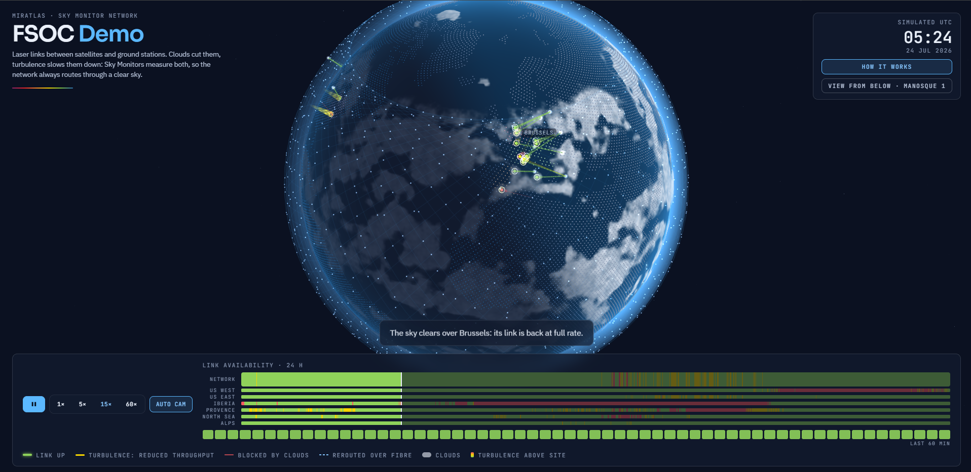
Until now, the decision to switch communications to another ground station in the network (site diversity) has been made reactively or on the basis of regional weather forecasts with limited spatial and temporal resolution. The Miratlas suite addresses this limitation by providing the network orchestrator with a real-time, sectorised and deterministic view of sky transparency.
Miratlas’s Multispectral Architecture
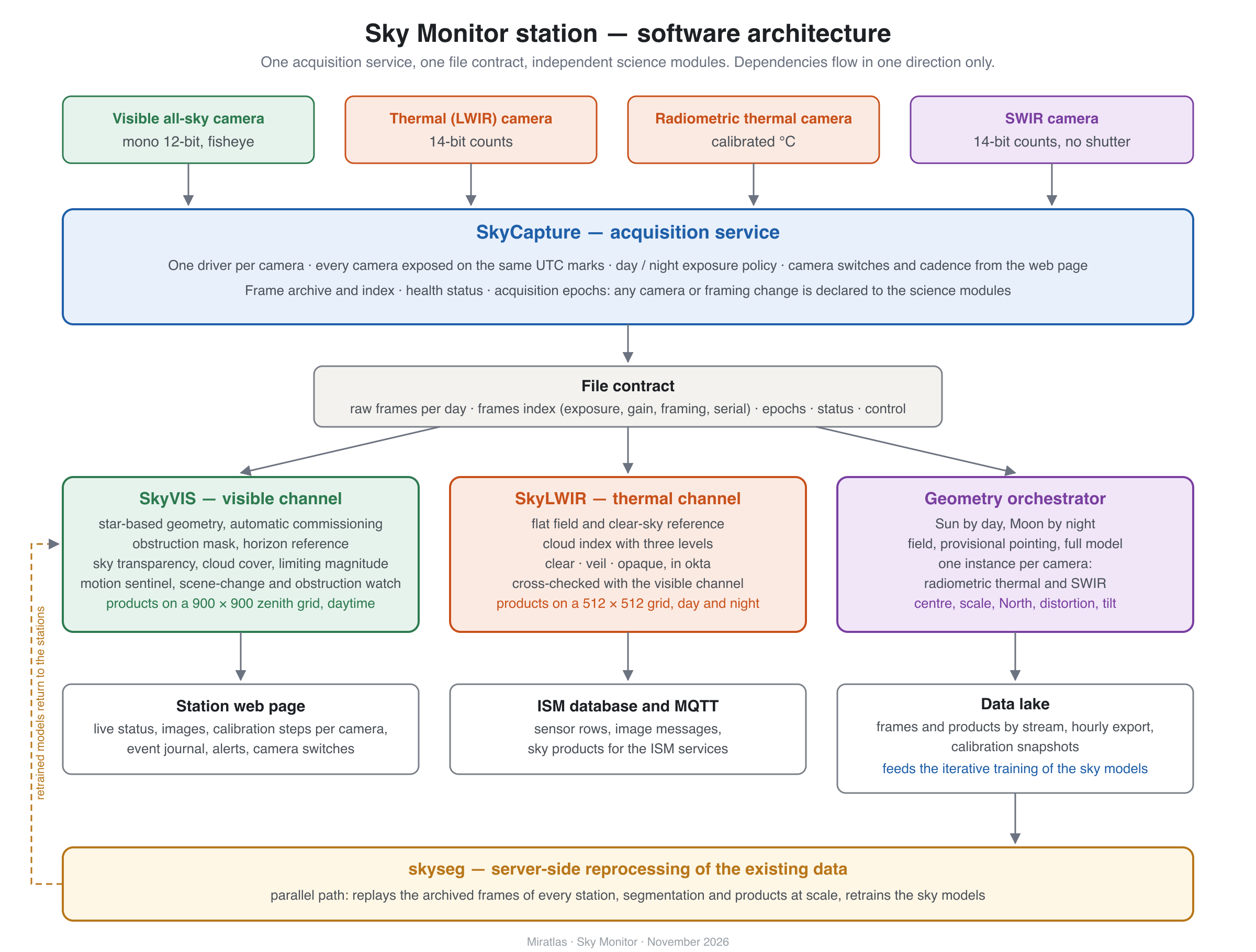
Miratlas’s atmospheric characterisation architecture is built around a modular hardware and software chain orchestrated by the Sky Monitors. This suite synchronises different optical and infrared sensors to cover the full range of observation and pointing requirements.
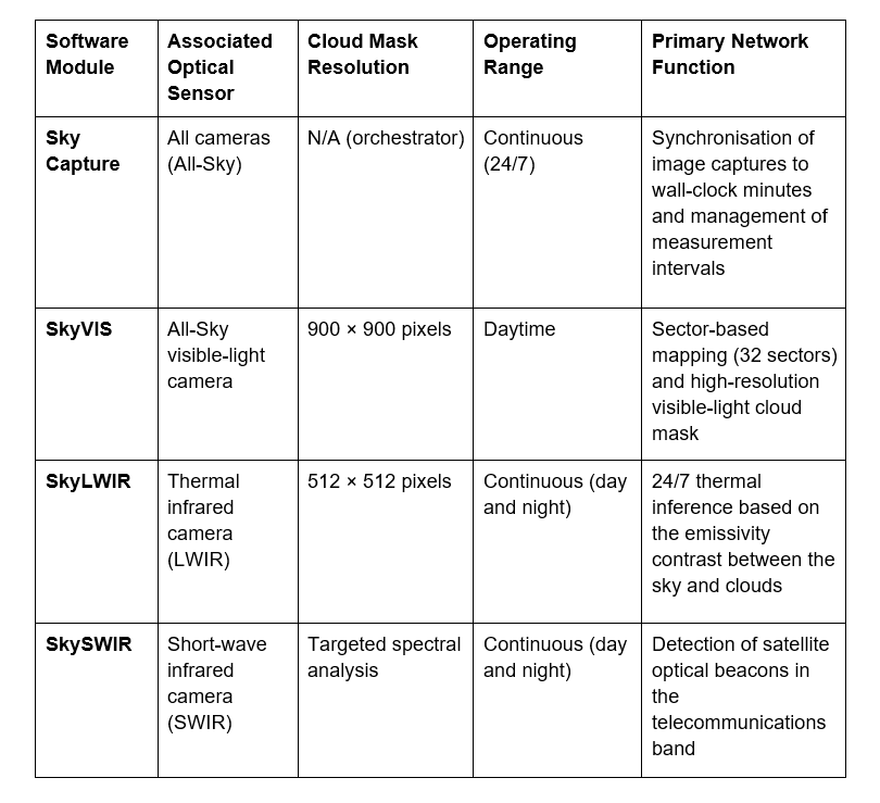
The table below summarises the respective roles and imaging specifications of the suite’s software modules:
The central role of the sky capture orchestrator
At the top of the local acquisition chain is Sky Capture. This orchestrator manages all cameras connected to the ground station and ensures that they are rigorously synchronised. Image acquisition is scheduled deterministically against the wall-clock minute (for example, 01h05m00s, 01h05m30s, etc.), with a configurable interval to suit the network’s operational requirements (in 30-second, 1-minute, 2-minute increments, or longer).
Daytime analysis and sky sectorisation with SkyVIS
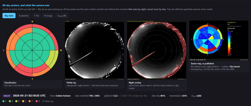
SkyVIS is the inference module dedicated to images captured by the All-Sky visible-light camera. During the day, SkyVIS divides the celestial hemisphere into 32 sectors (8 azimuth sectors combined with 4 elevation bands) and calculates actual optical transparency. In addition to this sector-based analysis, SkyVIS generates a high-resolution cloud mask of 900 × 900 pixels, enabling local cloud structures to be identified with a high degree of precision. At night, the visible-light camera complements the overall analysis by counting and tracking the extinction of stars from the catalogue.
24/7 Thermal monitoring with SkyLWIR
To ensure seamless continuity during both day and night, the SkyLWIR module takes over by processing the feed from a thermal infrared camera (Long-Wave Infrared, LWIR). Since a clear blue sky appears extremely cold in infrared radiation (down to -20 °C), while clouds emit warmer thermal radiation, SkyLWIR uses this direct physical reference to classify atmospheric conditions. It delivers a 512 × 512-pixel cloud mask around the clock, day and night.
Optical acquisition and beacon detection with SkySWIR
Specifically calibrated to operate in the spectral band allocated to laser telecommunications, the SkySWIR module uses short-wave infrared (SWIR) sensors. Its primary function is to detect, both day and night, the spectral signature of optical beacons emitted by approaching satellites. This facilitates initial acquisition and pointing by the ground-station telescopes before the actual transfer of data begins.
High-Performance training and autonomous Edge AI inference
To achieve a classification success rate of over 90–95%, the artificial intelligence models in the Miratlas suite were trained on industrial-grade computing infrastructure, using an inference server equipped with Nvidia Tesla A100 graphics processing units (GPUs).
The training dataset comprises more than 8,000 annotated and cross-referenced image pairs collected from six observation stations distributed across Europe. This network of stations covers a wide range of climatic conditions:
● The heavily overcast conditions of Northern Europe, illustrated in particular by the DLR (German Aerospace Center) station located in Trauen, Germany;
● The high-solar-irradiance conditions and variable cloud cover characteristic of the Mediterranean climate.
The result of this intensive training is a set of lightweight, autonomous neural networks. Deployed directly on the onboard computer of each field-based ISM station, the models perform inference locally. This decentralised architecture eliminates any dependence on a permanent connection to a remote data centre and preserves network bandwidth, ensuring maximum operational responsiveness and reliability.
Dynamic Ground-Station handover: network orchestration driven by sector-based transparency and the cloud mask
The key added value of the Miratlas solution lies in its ability to continuously feed the main satellite telecommunications network orchestrator with directly actionable physical measurements.
Every 30 seconds, the local ISM unit transmits the transparency matrix for all 32 sectors, together with the cloud-mask data (900 × 900 pixels for daytime visible imaging and 512 × 512 pixels for continuous LWIR monitoring). Through standardised and secure API interfaces, the operator’s orchestrator queries the ground station before and during the satellite pass.
When a three-minute LEO satellite pass offers only a 10-second usable optical transmission window between two cloud masses, the network orchestrator can immediately make the following traffic-management decisions:
Predictive rerouting: Redirect the data stream upstream to another optical ground station in the network located beneath a completely clear area of sky.
Hybrid arbitration: Temporarily switch the downlink or uplink to a high-frequency radio-frequency (RF) link or route it through the terrestrial backhaul network.
Optimisation of mechanical resources: Avoid unnecessary telescope-mount control and pointing operations when the clear-sky window is too short to establish a stable link.
Auto-Calibration, backward compatibility and the SaaS model
Beyond its atmospheric-analysis performance, the Miratlas suite integrates naturally into the operational and business models of modern telecommunications.
Celestial Auto-Calibration and pointing accuracy
Integrating the software suite eliminates time-consuming physical adjustment procedures during the installation of ISM stations. By automatically tracking the Sun’s trajectory during the day and identifying stars from the star catalogue at night (between 2,000 and 3,000 stars identified per clear-sky image), the system autonomously determines its geographical alignment and corrects optical distortions.
Software deployment and backward compatibility
The solution is a 100% software-based upgrade for existing installations equipped with visible-light All-Sky cameras. The entire fleet of Miratlas ISM stations already deployed in the field can receive this update without any hardware modifications, enabling operators to immediately expand their network-monitoring capabilities.
Software-as-a-Service (SaaS) business model
Offered through a recurring software subscription (Software-as-a-Service), the provision of sky-transparency and cloud-cover data is directly aligned with operators’ service commitments. By integrating the SkyVIS data stream in real time, the OGS network operator can secure its own 99.9% SLA and mitigate the risk of contractual penalties resulting from service outages. SkyVIS is available free of charge during the first year of SkyMonitor use and will also be available through Lamarck.